What does tool disagreement mean?
It means two products measured local visibility with different recipes, so their numbers are not the same observation.
Neither number is Google’s official rank. Google does not export a universal Maps position. Distance still changes what a searcher sees. Source: Tips to improve your local ranking on Google.
Is this the same as tracker versus Google?
No. That page is your live Search or Maps result versus one product. This page is vendor versus vendor.
Use why a local rank tracker differs from Google Search when the argument is “but I just searched it.” How to run a geo-grid at all is how to track Google Maps rankings.
Pin
Do both tools sample the same point? A 200-metre shift can change the local pack.List
Are they ranking the same list? Pack, Maps and organic positions are not interchangeable.Rule
Is “rank 3” defined the same way? Some products skip ads, Maps, or businesses without a website.Yes
Pick one method and keep it A trend needs a stable recipe, not two dashboards.Next
You versus Google is a different page Diagnose a phone search separately from two vendors.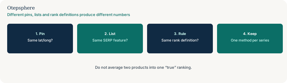
Can a settings change explain it?
Yes, if one tool used a wider radius or a denser grid than the other, or if you changed settings between scans.
A broken trend after you changed the recipe is why you cannot compare geo-grid rankings after changing the grid or radius.
What belongs in one tracking recipe?
Query spelling, language, sample coordinates, grid size, radius, result surface, and the vendor’s rank rule.
Write those down next to every export. If a second tool cannot match them, it is a second series, not a referee.
How do you pick a source of truth?
Pick the product whose recipe you can keep stable and whose surface matches the customer journey you care about.
Use Maps-oriented tracking if customers choose from the pack. Use Search Console for website queries. Do not average the two into one “true rank.” Measuring the geographic pattern is how to measure Google Maps visibility.
Vendor decision table
| What you see | What it usually means | Decision | What not to assume |
|---|---|---|---|
| Pins differ by a few hundred metres | Different searcher location | Align coordinates or accept two series | That one vendor is lying |
| One ranks the pack; one ranks organic | Different surfaces | Stop comparing the numbers | That “local rank” has one meaning |
| Scans hours apart on a volatile query | Time gap | Re-run both in the same window | That the later scan is the correction |
| You changed radius on only one tool | Recipe break | Use the settings-change guide | That Maps visibility crashed |
What should I not do?
Action checklist
- Write each vendor’s query, pin, surface and rank definition on one line.
- Align what you can. Label what you cannot as a second series.
- Pick one recipe for the trend you will actually manage.
- If the fight is with a phone search, switch guides.
- If someone changed grid size mid-month, switch to the settings-change guide.
- Do not average the exports.
When professional help makes sense
Help is useful when an agency and an in-house tool have never used the same pin. It cannot declare an official Google rank, and it cannot make two products identical. If one monthly process drifted between exports, that is incomparable monthly rank reports, not two tools.
Sources and further reading
- Google Business Profile Help: Tips to improve your local ranking on Google
- Google Search Central: How Search works
Two rank trackers still quoting different positions?
Otepsphere can document each tool’s recipe so you keep one series — not an average presented as Google’s rank.
Contact OtepsphereWho writes this
This page is published by Otepsphere, a specialist Local SEO consultancy. A named founder biography, photograph and professional profiles will be added here only when they have been verified. Until then, treat Otepsphere as the responsible organisation rather than a fictional expert.